Silent, Elusive, and Endangered: How Moreton Bay Uncovered a Thriving Greater Glider Population

What started as a single known population of endangered Southern Greater Gliders tucked away in Upper Caboolture has quietly grown into one of the region’s most exciting conservation discoveries in recent years.


Read: Moreton Bay’s Award-Winning Wildlife Network Puts Bribie and Morayfield on the Map


As recently as 2023, Sheep Station Creek Conservation Park was the only confirmed location of the Southern Greater Glider within the City of Moreton Bay. Today, that number has jumped to 11 sites, a dramatic expansion of the known range of a species that, until now, many assumed was barely hanging on in the region.

Photo credit: City of Moreton Bay

The breakthrough didn’t come from satellite imaging or scientific modelling. It came, in large part, from two dogs with very good noses.

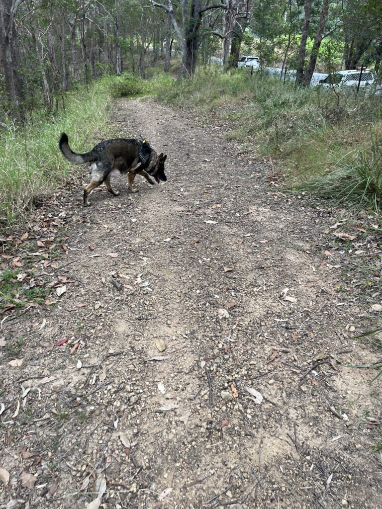
German Shepherd Ada and English Springer Spaniel Stanley, both trained to detect greater glider scats, spent the past three years sniffing through 40 Council-owned reserves and various Land for Wildlife properties alongside Council’s Environmental Services team and the National Environmental Science Program. 

Photo credit: City of Moreton Bay

DNA analysis of the scats collected by the dogs confirmed Southern Greater Gliders at 10 locations across Cedar Creek, Cashmere, Moorina, Bunya, Mt Nebo and Mt Glorious, in addition to the original Sheep Station Creek site.

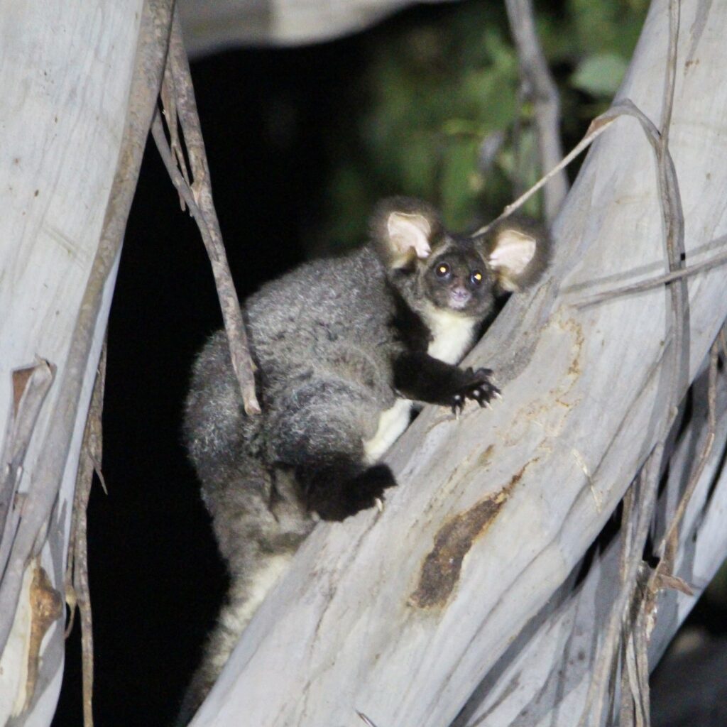
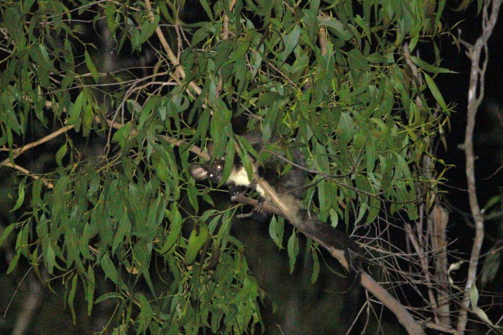
The Southern Greater Glider is no small find. Listed as endangered, the cat-sized marsupial, sometimes called the “flying koala” for its fluffy appearance and eucalyptus-heavy diet, is one of Australia’s most cryptic animals. Despite its distinctive large ears and long fluffy tail, it spends its days hidden inside large tree hollows, emerging only at night and making virtually no audible noise. Spotting one without knowing where to look is, to put it plainly, a matter of luck.

Meet Ada and Stanley, the Dogs Behind the Discovery

Photo credit: City of Moreton Bay

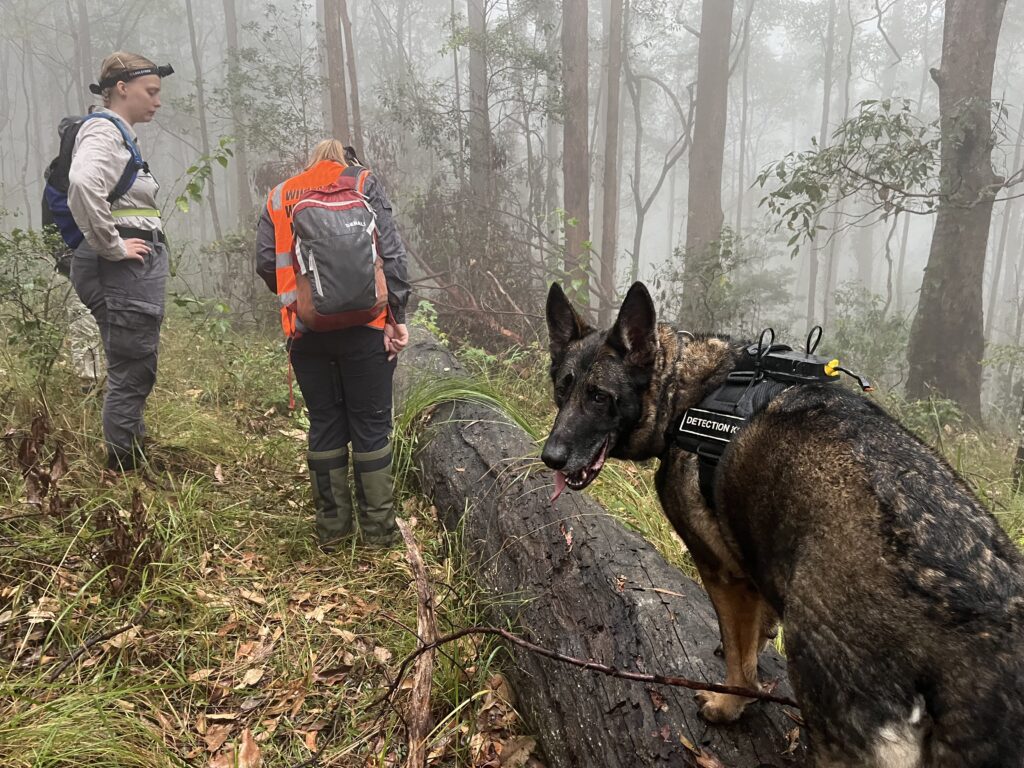
That’s precisely why the detection dogs proved so valuable. Their handler, animal trainer Nicky Wright, said both Ada and Stanley were raised and trained specifically for this kind of survey work, with Ada also cross-trained on koala scats.

“We would try to use fire trails and tracks to walk on and send the dog off; when they find a scat they demonstrate a change in behaviour and then present their find,” Wright explained.

Photo credit: City of Moreton Bay

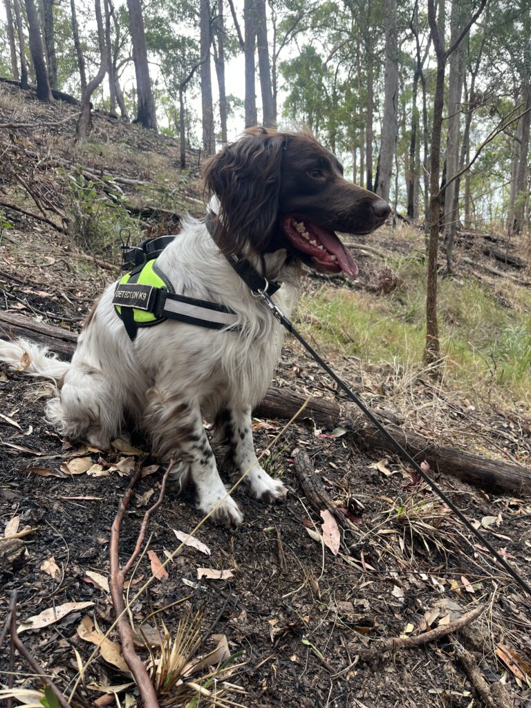
“Ada sometimes found koala scats, which look very different to that of a greater glider. On some sites we found so many greater glider scats there was no longer the need to keep looking!”

It’s a detail that speaks to just how significant some of these newly confirmed populations appear to be.

City of Moreton Bay Mayor Peter Flannery said the results were a meaningful development for a species under pressure across much of its range.

“We thought it didn’t make sense that Southern Greater Gliders would only be living at Sheep Station Creek Conservation Park given the amount of suitable habitat in our City,” Flannery said. “We’ve been incredibly pleased to discover so many places where the marsupial has been hiding out.”

“The substantial presence of this endangered species is yet another example of the exceptionally rich biodiversity that exists in our City.”

The project is far from finished. Council is preparing to deploy thermal drone technology to search for Southern Greater Gliders in reserves where the terrain is too rugged or inaccessible for ground surveys, following a successful trial already completed at Sheep Station Creek Conservation Park.

Residents across the City of Moreton Bay are also being asked to keep their eyes open. Council has been distributing flyers encouraging locals to look for Southern Greater Gliders on their own properties. You don’t need specialist equipment. A regular torch will do. The gliders have a distinctive golden eye shine that reflects back in the beam of a light at night.

If you spot one, reporting it matters. Sightings from the community play a genuine role in building a clearer picture of where this species is living and how best to protect it.


Read: Wildlife in Caboolture Area Get New Homes as Water Project Progresses


For a marsupial that makes no sound and hides in hollow trees, the Southern Greater Glider has a way of turning up somewhere unexpected, as Moreton Bay is now finding out, one scat at a time.

Residents who spot a Southern Greater Glider on their property are encouraged to report the sighting to the City of Moreton Bay. For more information, visit the Council’s website.

Featured image credit: City of Moreton Bay

Published 28-April-2026

Construction Starts on Beachmere’s $295 Million Over-50s Waterfront Community

Construction has officially begun on GemLife Beachmere Waterfront, a $295 million over-50s land lease development on Gillian Street in Beachmere that will deliver 335 homes across a 62-hectare site beside the Caboolture River, with first residents expected to move in by the end of 2026.


GemLife Managing Director and Group CEO Adrian Puljich marked the start of works at a sod-turning ceremony on 23 April, joined by local community representatives.

The three-year project is expected to create around 400 jobs across housing construction, resort amenities and road upgrades, including new turning lanes and the widening of a section of Beachmere Road. A further $2.5 million will be spent on infrastructure as part of the development.

For a coastal township that has long sat in the quieter corners of Moreton Bay’s growth story, the scale of investment arriving on Gillian Street represents a significant shift.

A site designed around what’s already there

One of the most striking aspects of GemLife Beachmere Waterfront is how much of the 62-hectare site will remain untouched.

More than 80 per cent of the site will remain untouched, headlined by a 52.1-hectare wetland reserve. GemLife will rehabilitate this natural corridor before formally transferring the land to the City of Moreton Bay as a permanent, protected public asset.

Photo Credit: GemLife

At the heart of the site, an existing 1.1-hectare artificial lake with a tidal connection to the Caboolture River will be preserved and enhanced as a central feature of the community. A network of walking and cycling trails will thread through the wetland reserve, giving residents direct access to one of the bayside region’s most significant natural corridors.

GemLife Beachmere Waterfront is located 58 kilometres north of Brisbane in Beachmere, a coastal rural town, close to Beachmere Shopping Centre, local restaurants and Main Beach, with Caboolture just 15 minutes away.

What life inside will look like

The $15.5 million Country Club will anchor the community’s social heart, overlooking both the lake and the Caboolture River. Inside, residents will find an indoor heated pool, cinema, hall, bar and café, salon, golf simulator, lawn bowls, art room and dance floor, alongside a separate Summer House with an outdoor pool.

Photo Credit: GemLife

The homes themselves are designed around the sub-tropical climate, with open-plan indoor-outdoor living, generous outdoor spaces, solar panels connected to battery storage and access to GemLife’s 5G wireless internet network. Two-bedroom plus multipurpose-room homes are priced from $815,000. A weekly site fee covers all maintenance, management and amenities, with no stamp duty, entry or exit fees applicable.

Meeting a real gap in Moreton Bay’s housing supply

The Beachmere development addresses a genuine and growing demand. Early interest shows a distinct regional draw; while around a third of enquiries are coming from locals within a 30-kilometre radius, nearly half are from buyers in the 30 to 100-kilometre bracket looking to secure a spot on the coast.

GemLife
Photo Credit: GemLife

The land lease model GemLife uses is distinct from a traditional retirement village. Residents own their homes outright and lease the land beneath them, retaining 100 per cent of any capital gains if they choose to sell, with no exit fees attached. That structure, combined with a one-level home format right-sized for active over-50s, has driven strong demand across GemLife’s existing Moreton Bay communities.

GemLife Beachmere Waterfront is GemLife’s fourth land lease community in Moreton Bay, joining GemLife Moreton Bay in Burpengary East, GemLife Bribie Island and GemLife Elimbah, bringing the total number of homes it is delivering across the region to more than 1,685.

The City of Moreton Bay is expected to welcome 210,000 additional residents over the next two decades, and GemLife has consistently positioned its regional investment around that long-term trajectory.

When to expect the first homes

GemLife Beachmere Waterfront will be released to market in June, in line with the opening of its onsite sales office. The first homes are expected to take shape from mid-2026, with first residents anticipated to move in before the end of 2026.

For more information or to register interest, visit click here or contact GemLife directly on 1800 GEMLIFE.


Published 27-April-2026

Featured Image Credit: GemLife

Morayfield South Set for 26,000 Residents as New Planning Rules Move Forward

Morayfield South is being mapped out to house about 26,000 people, with new roads, schools and stricter bushfire building rules proposed as part of a major planning shift by the City of Moreton Bay.


The proposal follows community consultation held from 13 October to 7 November 2025 and was endorsed at a council general meeting on 22 April 2026, where councillors agreed to seek approval from Queensland Deputy Premier and Minister for State Development, Infrastructure and Planning Jarrod Bleijie.

Detailed structure plan reshapes how Morayfield South will function

The City of Moreton Bay has put forward Major Planning Scheme Amendment No.4, outlining not just where growth will occur, but how the suburb will be designed day to day. According to a City of Moreton Bay media release, the plan introduces a structure that connects homes, schools and public spaces through a network of roads, pathways and community hubs.

Planning documents show the proposal goes further than earlier versions of the area’s blueprint. Environmental corridors have been expanded and refined to better protect vegetation and link green spaces across the suburb. New walking and cycling routes are also planned alongside these corridors to connect residents to parks, schools and local centres.

Changes to the road network are also included, with a revised road hierarchy designed to handle future traffic while avoiding sensitive environmental areas. A previously proposed road link between Oakey Flat Road and Clark Road has been removed after further assessment found it could impact an environmental corridor.

Key changes shift earlier plans for transport and local centres

Some earlier ideas for the suburb have been reworked or removed entirely. Planning documents indicate a previously proposed train station has been taken out of the plan following further investigation and advice from the State Government. The surrounding land has instead been reallocated for new neighbourhood development while retaining environmental protections.

Community feedback has also led to changes in where key facilities will be located. A local centre and community hub originally planned for one area has been moved to the corner of Hauton Road and Blewers Road, while some district parks have been relocated to better meet expected demand and accessibility standards.

Council planning material indicates the suburb will be built around walkable neighbourhoods, where homes, shops and services are positioned within close reach of each other, supported by active transport links.

Click to Enlarge
Photo Credit: City of Moreton Bay

Bushfire rules extend across Moreton Bay suburbs

Beyond Morayfield South, the amendment also changes how bushfire risk is managed across the wider City of Moreton Bay. The proposal removes existing exemptions that allowed some buildings in residential, township, centre and industry zones to avoid meeting national bushfire safety standards.

Under current rules, certain homes and facilities can be built in bushfire-prone areas without complying with National Construction Code requirements. The amendment would extend those requirements to more building types, aiming to improve safety outcomes as development continues across the region.


Community feedback shapes final proposal

Residents who took part in the consultation process will be able to review how their feedback was considered, with Cr Tony Latter noting community input was used to refine the proposal before it was sent to the State Government.

The final decision now rests with the state, which will review the amendment and determine whether it can proceed, either as proposed or with conditions. If approved, the City of Moreton Bay will formally adopt the changes and begin implementing the updated planning framework.

Published 27-April-2026

Featured Image Credit: Supplied

25,000 Tickets Gone in 12 Hours: How Caboolture’s Medieval Festival Became Australia’s Best

The Abbey Medieval Festival has sold out all 25,000 tickets for its 35th anniversary edition in under 12 hours, just weeks after winning gold at the national Qantas Australian Tourism Awards to be officially crowned Australia’s best festival.


The sell-out, which crashed the ticketing website under the weight of demand, caught even the organisers off guard. Events and Public Programs Manager Joel Stephens said the scale of the response was unlike anything the festival had experienced before.

“Selling out so quickly was a definite surprise,” Stephens said. “We were not expecting the huge demand we saw yesterday and a full sellout in less than 12 hours. It shows how popular and exciting the festival is.”

The ticketing platform buckled under the surge. Stephens acknowledged the team had made some improvements to the booking process before the sale opened, but the adjustments had the opposite effect to what was intended.

“It was a little bit of a perfect storm, to be honest,” he said. “We made some improvements to the process, made a few tweaks and unfortunately they backfired a little bit. But we’re constantly working to improve the systems and structure in place and deliver the smoothest experience possible to our customers.”

All tickets, including Saturday, Sunday and the Friday Family Fun Day on 10 July, are now fully sold out. No further tickets will be made available. Organisers recommend using the official resale partner Tixel for those seeking returned tickets. 

From Queensland Gold to National Champion

The sell-out arrives at the peak of a remarkable run for the festival. In November 2025, the Abbey Medieval Festival took gold at the Queensland Tourism Industry Council Awards in the Festivals and Events category, becoming the state’s nominee for the national competition.

Then in March 2026, it went all the way, winning gold at the prestigious Qantas Australian Tourism Awards, beating more than 170 finalists across 26 categories to be recognised as Australia’s best festival. Perth’s Subi Blooms x Gather festival took silver, while South Australia’s Streaky Sounds Music Festival claimed bronze.

Stephens said the national result caught the team just as off guard as the ticket sell-out.

“We won the Queensland Tourism Industry award late last year which put us in the running for the national awards and were not expecting to take that out,” he said. “So we’re really honoured the judges looked at the festival we offer and had the same feeling the public does.”

The award recognised not just the scale of the event but the effort behind it. The festival runs with more than 300 volunteers and draws more than 1,000 reenactors, performers and speciality stallholders to Abbeystowe each July.

What July 10-12 Holds for Ticket Holders

For the 25,000 people heading to Caboolture on 10, 11 and 12 July, the 35th anniversary edition promises everything that has made the festival a national landmark event, with the added weight of a milestone year.

The festival spans approximately 600 to 1600AD in European and Middle Eastern history, and the programme brings that breadth to life across three days. The Moreton Bay Medieval Joust Championship, where Australia’s top jousters compete at speeds of 30 kilometres per hour, runs three sessions on both Saturday and Sunday, with the grand final on Sunday at 3pm to crown the new champion.

Knight combat, Turkish oil wrestling, archery, Birds of Prey demonstrations, storytelling, period music, traditional dancing and interactive encampment activities fill out the programme across the weekend.

The Friday Family Fun Day on 10 July is the festival’s sensory-friendly day, designed to welcome visitors who have challenges with learning, communication, understanding and behaviour, including people with autism, intellectual disability, Down syndrome and acquired brain injury. The Knighting Ceremony on Friday is a separate, strictly limited ticketed event.

Kids Kingdom, a dedicated children’s activity area, operates on Friday and Saturday. On Sunday, the space transitions to the University Pavilion, with a schedule of presentations.

A New Festival Is Coming in September

The Abbey Museum is not stopping at July. Stephens confirmed the team is also developing a brand-new event: the Abbey History Festival, locked in for 26 and 27 September 2026.

“Our main festival does have a limit on the timeline in terms of the Middle Ages, so we’re looking to launch the Abbey History Festival,” he said. “This will bring a broader timeline of re-enactments, culture and food to our Abbey Precinct helping us celebrate 40 years of the Abbey Museum, which is what all this goes to support.”

The Abbey Museum of Art and Archaeology, which the festival exists to support, holds one of Australia’s most significant collections of medieval and ancient artefacts, including rare examples of European, Asian and Pacific material culture.

Getting to Abbeystowe

The festival is located at 1-63 The Abbey Place, Caboolture, off Old Toorbul Point Road. A free shuttle bus service operates every 30 minutes from Caboolture train station from 7.45am on both Saturday and Sunday.

Paid parking passes at $11 per vehicle are required for Saturday and Sunday on-site parking, with proceeds supporting the Wamuran Progress Society. Free parking is available on the existing site on Friday. A disability car park is available for permit holders, located approximately 250 metres from the front gate.

Festival ticket holders can also use their ticket for one free entry to the Abbey Museum before 30 September 2026. For more information, visit abbeymedievalfestival.com or contact the Abbey Museum on (07) 5495 1652.


Published 24-April-2026

Featured Image Credit: Abbey Medieval Festival

Caboolture Crash Claims Life Of Three-Year-Old Girl During Evening Walk

A three-year-old girl has died after being struck by a ute while walking with her family in Caboolture, with investigations continuing into the fatal traffic incident.


Evening Walk Ends In Fatal Caboolture Crash

The incident occurred on 21 April near the intersection of Lynfield Drive and Toohey Street in Caboolture. The child was walking with her mother, grandmother and younger brother when, at approximately 6:47 pm, a Nissan Navara utility turning right from Lynfield Drive onto Toohey Street struck her.

Paramedics attended and treated the girl for critical injuries, however she died at the scene.

Family Seen Moments Before Collision

In the minutes before the incident, the family had been walking home from daycare along the road. CCTV footage captured the group shortly before the collision, showing an adult walking with the child and another woman pushing a stroller.

Two women and a male toddler were later transported to Caboolture Hospital in stable condition, experiencing emotional distress.

Caboolture crash
Photo Credit: QPS/Facebook

Driver Assisting Investigation In Caboolture

The driver of the ute, a 49-year-old Caboolture woman, remained at the scene and is assisting police. The Forensic Crash Unit is investigating the circumstances surrounding the collision.

Investigators are examining the events leading up to the incident, including movements in the moments before impact. Police have urged anyone with relevant CCTV or dashcam footage from the area to come forward.

Tributes Mark Scene In Caboolture

Flowers and a small teddy bear have been placed at the site following the incident. The child has been described as affectionate and full of energy, with her loss reflected in tributes left at the location.

Investigation Continues After Caboolture Fatality


Investigations remain ongoing as authorities work to establish how the collision occurred. Police continue to appeal for information that may assist in clarifying the circumstances surrounding the fatal crash in Caboolture.

Published 23-Apr-2026

Photo Credit: QPS/Facebook

The Railway That Helped Shape Caboolture’s ANZAC Roots

Most people know Caboolture today as one of South East Queensland’s busiest and fastest-growing communities. But long before housing estates and busy roads arrived, Caboolture was a quiet farming district built around a railway line — a line that would become deeply connected to the region’s wartime history. That connection still runs through the suburb today.

In the early 1900s, Caboolture sat along the North Coast rail line, one of Queensland’s most important transport corridors. Trains carried dairy produce, livestock and supplies south to Brisbane, while also linking regional communities across the state.

During wartime, those same tracks carried young men leaving for service. Historical records archived show ANZAC Day commemorations taking place in Caboolture as early as the 1920s, revealing how closely the district identified with remembrance and military service even a century ago.

At the time, Caboolture was still a rural settlement surrounded by dairy farms and small agricultural properties. Families depended on the land, and the railway station formed the centre of community life.

When troop trains passed through, residents gathered along the platform to farewell local servicemen. Fruit, cigarettes and handwritten notes were passed through carriage windows as trains prepared to leave.

Girls’ patriotic tableau at Caboolture during World War 1, holding aloft various flags and the letters spelling ‘Fighting for liberty’. One girl sits in the centre of the group representing the allegorical figure of Liberty. Photo credit: State Library of Queensland

By 1916, the impact of the First World War was already being felt across the district. Short notices published in newspapers quietly recorded the names of local men killed or wounded overseas. Behind each line was a farming family suddenly missing a son, a brother or a worker. The war changed everyday life in ways that extended far beyond the battlefield.

A notice published at the time shows how that loss was recorded. Photo Credit: Trove

Life Along the Rail Corridor

Caboolture’s railway line did more than move people — it helped shape the entire district. The farms surrounding the town supplied Brisbane with milk, produce and other essentials during the early decades of the 20th century. The rail corridor allowed rural communities like Caboolture to remain connected to the growing capital.

In the years after World War I and World War II, returned servicemen across Queensland were encouraged to rebuild their lives through farming and rural settlement programs.

Farm in Upper Caboolture Photo Credit: Public domain/State Library of Queensland

Nearby districts such as Beerburrum became associated with agricultural training and settlement schemes designed to help veterans transition back into civilian life.

Caboolture also played a role in maintaining wartime morale. Community events, patriotic fundraisers and public gatherings became common throughout the war years. One striking historical photograph preserved by the State Library of Queensland shows local girls during World War I standing beneath banners spelling out the words “Fighting for liberty”, reflecting how deeply the war effort touched even small rural towns.

During World War II, the region again became strategically important. Troops stationed near Caboolture helped construct temporary river crossings and transport infrastructure used to move men and supplies through Queensland during the later stages of the war.

Troops constructing a river crossing in Caboolture for the transport of men and materials, 1945. Photo Credit: Australian War Memorial

A History Still Running Through the Town

Although modern Caboolture looks very different from the farming district it once was, parts of that history remain surprisingly visible.

The same railway corridor that once carried produce and servicemen still cuts through the suburb today, continuing to connect Caboolture with Brisbane and regional Queensland.

Many of the district’s old farming areas have gradually transformed into residential neighbourhoods, but the town’s identity continues to reflect the same foundations that shaped it generations ago — movement, connection and community.

Caboolture’s ANZAC story is therefore not just about memorials or ceremonies. It is woven into the district itself: into the rail line, the farms, the wartime farewells and the generations of local families whose lives were shaped by service and sacrifice.

Published 23-April-2026

Smoke Drifts Across Moreton Bay as Planned Burn-Offs Begin

Residents across Moreton Bay are waking to smoke drifting over suburbs as planned burn-offs begin across bushland areas, with fire crews lighting controlled fires to reduce the threat of bushfires before peak season. From Bribie Island to Upper Caboolture, these managed burns are already affecting nearby communities, with smoke expected to hang in the air for days even after flames are extinguished.


The burns began with activity recorded around April 15 and continuing through April 16, according to local authorities. Crews carried out operations in areas including Bribie Island, particularly near Mermaid Lagoon, as well as Upper Caboolture, while new sites such as Albany Creek were scheduled to follow as conditions allowed.

Smoke spreads beyond burn zones into nearby suburbs

While the fires are controlled, the effects are not limited to the burn sites themselves. Smoke from operations near Banksia Beach has been reported drifting into nearby areas such as Toorbul and Sandstone Point, affecting visibility and air quality. Authorities have advised residents, especially those with respiratory conditions, to stay indoors and keep windows and doors closed when smoke is present.

Even after a burn is completed, crews continue to patrol and monitor the area for several days to ensure the fire remains contained. This means some suburbs may continue to experience smoke or restricted access beyond the initial burn period.

Photo Credit: City of Moreton Bay/YouTube

Moreton Bay hazard reduction burns: affected suburbs and status

Suburb / AreaBurn StatusCommunity Impact
Bribie Island (Banksia Beach)Completed / RecentSmoke lingering, monitoring ongoing
Upper CabooltureCompleted / RecentPossible residual smoke, patrols in place
Albany CreekScheduled / Likely underwayPossible smoke if conditions met
ToorbulIndirect impactSmoke drift reported from nearby burns
Sandstone PointIndirect impactSmoke drift affecting area
BellaraPlannedFuture burn, timing dependent on weather
BurpengaryPlannedFuture burn, no fixed schedule
CaboolturePlannedFuture burn, no fixed schedule
Deception BayPlannedFuture burn, no fixed schedule
GriffinPlannedFuture burn, no fixed schedule
Mount GloriousPlannedFuture burn in bushland areas
NingiPlannedFuture burn, timing to be confirmed
WhitesidePlannedFuture burn, no fixed schedule
WoodfordPlannedFuture burn, rural bushland areas

No fixed schedule as weather dictates next burns

Although more than a dozen additional burn sites have been identified across Moreton Bay, including Burpengary, Deception Bay, Griffin and Woodford, there is no set timetable for when each location will be treated. Authorities rely on specific weather and environmental conditions before lighting any fire, meaning plans can shift quickly.

Burn season typically runs from March to August, but officials note that operations can take place at any time of the year if conditions are safe. This flexible approach is designed to ensure each burn can be carried out with minimal risk to surrounding communities.

Balancing fire prevention with environmental care

Officials say the burns play a key role in reducing fuel loads such as dry leaves and fallen branches, which can feed dangerous bushfires during hotter months. At the same time, the process is managed to protect local wildlife and vegetation.

Before each burn, teams assess the site to identify sensitive habitats and species. Measures such as clearing around trees and monitoring wildlife during the burn are put in place. The use of aerial incendiary drones has also been introduced to help crews ignite fires more precisely, particularly in hard-to-reach terrain.

Authorities say these planned burns also support the natural cycle of some native plants, which rely on fire or smoke to trigger growth and seed release, helping maintain the region’s biodiversity.


Published 20-April-2026
Featured Image Credit: City of Moreton Bay/YouTube

St Eugene College Students Raise More Than $8,000 for Charity, Living Out Their Patron’s Easter Mission

Students at St Eugene College in Burpengary raised more than $8,000 for Caritas Australia’s Project Compassion this Easter, living out the legacy of their patron saint through a season of fundraising, community action and a conviction that small, shared gestures can change lives for people doing it tough.


For families in Burpengary and across the Caboolture corridor who know St Eugene College as the local Catholic secondary school, the result is more than a fundraising figure. It is a demonstration of what the school’s community actually looks like when it puts its values into action.

Carrying the Mission of a Patron Saint

St Eugene de Mazenod, the French bishop who founded the Missionary Oblates of Mary Immaculate in the early nineteenth century, built his life around reaching people who had been forgotten by society. His mission was charity in the most literal sense: going out to those at the margins rather than waiting for them to arrive at the door.

St Eugene College draws its name and spirit from St Eugene de Mazenod, a French bishop who dedicated his life to those on the outer. This Easter, students brought that legacy into the present day. Rather than waiting for a call to help, the college community reached out, grounding their fundraising in the belief that belonging means looking after our global family.

Their fundraising for Project Compassion, Caritas Australia’s annual Lenten appeal, channelled that spirit directly. Project Compassion supports some of the world’s most vulnerable communities through long-term development programs across more than 100 countries. Every dollar raised by St Eugene College students this Easter connects to that work.

More Than $8,000 and the Meaning Behind It

The fundraising total of more than $8,000 reflects the kind of effort that requires genuine buy-in from students across year levels, not just a single event or a token collection tin. House initiatives spread the responsibility and the energy across the whole college, while whole-school events brought the community together around shared purpose.

The college’s aim was clear: to demonstrate that small actions, taken collectively, carry real weight. That a group of students in Burpengary can raise more than $8,000 for people experiencing poverty on the other side of the world is precisely the kind of outcome the Easter season asks communities to strive toward.

St Eugene’s efforts mirror a broader wave of generosity across Brisbane Catholic Education schools. While St Ignatius in Toowong celebrated with a hat parade and donation drives, the Burpengary community focused on the power of the “shared gesture.” As St Ignatius principal Benedict Campbell noted, this season is an invitation to walk alongside others, a call the St Eugene students answered with one of the region’s strongest fundraising tallies.

The Easter Invitation to Look Outward

What St Eugene College has done this Easter is not unusual in the context of Catholic education, but it is worth naming. Secondary school students who might otherwise spend their final weeks of term focused entirely on assignments and sport chose instead to organise, fundraise and think about people whose lives look nothing like their own.

That orientation, outward rather than inward, is at the heart of what Easter calls communities to do. Jesus’ Passion and Resurrection are not a private story; they are an invitation to respond to suffering in the world with care, generosity and action. St Eugene College’s students took that invitation seriously.

A Community Worth Being Part Of

For Burpengary and Caboolture families with children at or approaching secondary school age, St Eugene College’s Easter effort is a window into what the school’s community culture looks like day to day. Schools that raise more than $8,000 for Caritas in a single term do not do so by accident. They do so because the values are embedded, the teachers model them and the students feel genuinely connected to something larger than themselves.

That is the kind of school community that forms more than just exam results.

More information about St Eugene College, Burpengary is available through the Brisbane Catholic Education website at bne.catholic.edu.au.


Published 8-April-2026

Featured Image Credit: St Eugene College/Facebook

Ancient Caboolture Earthquake Sheds Light on Future Disaster Planning


A powerful earthquake that struck near Caboolture tens of thousands of years ago is now helping researchers and local authorities understand how a similar event today could affect homes, roads and essential services across the region.


Researchers from the University of Melbourne, working with City of Moreton Bay, have been studying a fault line west of Caboolture believed to have produced a quake of magnitude 6.5 or higher between 20,000 and 35,000 years ago. Their work combines aerial mapping and on-ground excavation to better understand the scale and impact of that ancient event.

Mapping the past to prepare for the future

The project uses LiDAR, a laser-based mapping system, to scan the landscape and detect subtle changes in the ground that point to past earthquakes. These scans help identify where the earth’s surface may have split during earlier seismic activity and where similar breaks could occur again.

Scientists then dug trenches across the fault line to examine layers of soil and sediment. This tells what has been shifted or left undisturbed, so that the experts can estimate when the earthquake occurred, how strong it was and how far the ground moved. This process, often described by researchers as geological detective work, helps build a clearer picture of earthquake risks in the region.

Findings from these tests are now being analysed, with results expected to confirm earlier mapping and refine estimates of the quake’s timing and size.

Where the fault runs

Geological mapping helps show where the fault sits in relation to the Caboolture district and the North Pine Dam area.

The first map, from the Caboolture 1:100,000 Geology Map Compilation 2014, covers places named on the extract, including Caboolture, Bracalba and Bellmere. The second map, from the Esk 1:100,000 Geology Map Compilation 2014, covers the North Pine Dam, Mount Samson and Clear Mountain area.

Photo Credit: QLD Geoscience Data

These maps do not prove the age or size of a single earthquake on their own, but they do help locals see where mapped fault traces run across the landscape and how those traces relate to surrounding rock and sediment units. It can add to the understanding of why scientists are focusing on this part of South East Queensland. 

Understanding the risks for growing communities

While earthquakes are less common in Queensland than in other parts of the world, they are still considered a natural hazard. State-level risk assessments place earthquakes among the lower-tier risks, but experts warn that even a moderate event can cause serious damage, especially in growing urban areas.

Local officials say understanding the Caboolture fault will help guide future planning decisions, including how infrastructure is built and how emergency services respond. The data is also being shared with agencies such as the Queensland Fire Department and utility providers to improve preparedness.

No written history, but a geological record

Because the earthquake occurred long before recorded history, there are no human accounts of the event. Instead, the story is preserved in the land itself through fault scarps and disturbed sediment layers.

National data from Geoscience Australia shows that hundreds of similar features exist across the country, each marking evidence of prehistoric earthquakes. These features are key to understanding where future seismic activity may occur.

In South East Queensland, several fault scarps have been identified in recent years, reinforcing the need for ongoing research in areas not traditionally known for earthquakes.

Building a clearer risk picture

Researchers involved in the Caboolture study say combining mapping, trenching and dating techniques allows them to create realistic scenarios of how a future earthquake might unfold. This includes modelling ground movement, potential damage zones and the likely impact on infrastructure.


This information is valuable in shaping building standards, land-use planning and disaster response strategies. It also supports long-term efforts to ensure communities are better prepared for low-frequency but high-impact events.

Published 15-April-2026
Featured Image Credit: City of Moreton Bay

Rail Closures Stretch Commutes and Patience on Brisbane’s Northern Line

Commuters travelling from Caboolture, Morayfield and Burpengary into Brisbane faced severely disrupted journeys from April 10, with buses replacing trains on their line for the first three days of the closure period and replacement services struggling to keep pace with the volume of passengers turning up at transfer points.


For those who make the daily journey from the Caboolture corridor into the city, this week was a sharp reminder of just how much their commute depends on a functioning rail connection, and what happens when that connection breaks down without adequate contingency in place.

What Happened at the Transfer Points

Joanne McCarthy’s experience on April 10 captures what many Caboolture commuters faced that morning. Her journey from Caboolture to Roma Street, which normally takes one hour, stretched to two and a half hours. Passengers were directed off trains at Geebung, where a line of hundreds of people was already waiting on the rail bridge before 7am.

Commuters left stranded due to rail closures
Photo Credit: Translink

“There were no buses there waiting for us,” McCarthy said. She waited 45 minutes in the heat before boarding a bus, with no information coming through about when services would arrive or what was happening.

“We had no communication whatsoever about what was happening. I was thinking about jumping in an Uber, but you couldn’t even get to the front of the line to get down the stairs to get an Uber.”

That experience, of being stranded mid-journey with no information and no clear path forward, was repeated across dozens of commuters redirected from the northern corridor into the Geebung and Northgate bus replacement queues.

Why the Queues Got So Bad

Thompson Bus Services, contracted to run replacement buses across southeast Queensland, was caught off guard by the volume of passengers. Demand surged 50 per cent above what the company had anticipated, and the result was queues that stretched 300 metres at the worst points and 45-minute waits just to board.

Photo Credit: Thompson Bus Services

By Monday afternoon, 10 additional services had been scheduled for the evening peak, and further services were added for Tuesday morning. Founder Jeanie Thompson acknowledged the shortfall directly.

Translink orders the buses and we provide them, there was a lot more people than they originally thought,” she said. “We were caught out a bit on Monday morning.”

The company brought in 100 buses from interstate and mobilised every available bus in the southeast corner. At peak, it was coordinating 600 bus driver shifts a day across roughly 300 buses, and was still advertising for additional drivers and customer service staff during the disruption period.

Photo Credit: epifrenetic/Reddit

The comparison with normal service gives the scale of the problem context. Rail replacement buses on the affected northern corridor arrived roughly every eight minutes. In a normal morning peak, the combined rail network funnels a train through the inner-north corridor every three minutes. That gap, from three-minute frequency to eight-minute frequency, multiplied across a network handling thousands of passengers, produced the queues that Caboolture commuters found themselves joining at transfer points.

The Caboolture Line Schedule: What Changed and When

For Caboolture, Morayfield and Burpengary commuters, the schedule tells the specific story. Buses replaced trains between Gympie North and Caboolture on April 10, 11 and 12. From April 13, Sunshine Coast line trains resumed running between Gympie North and Caboolture, meaning that the direct northern leg of the journey returned to rail on that date.

The transfer problem, however, persisted. Even with the northern leg back on rail, commuters still faced the disruption zone between Northgate and Bowen Hills, which continued through to April 16 before reopening. Getting from Caboolture into the city still required navigating a transfer, and those transfers remained subject to the delays and queuing that defined the first week of closures.

The broader network picture extends further. Disruptions on the Beenleigh and Gold Coast lines continue through April 30, and the southern inner gap between Banoon and Boggo Road remains in place for the same period. For commuters whose journeys connect across these corridors, the impact stretches well beyond the initial week.

The Bigger Picture for Northern Corridor Commuters

South East Queensland Transport Association founder Imogen Buckley described the scenes at replacement bus stops as damaging to public transport’s reputation at exactly the wrong moment.

“The fact that there are commuters waiting on the platform for a line that stretches outside of the station, it’s embarrassing; it makes public transport look terrible,” she said.

Buckley was clear that the track closures themselves were a necessary part of maintaining and improving the network. “We need better infrastructure so we can have less track closures in the future and have a frequent and reliable network,” she said. The problem was not the decision to close tracks for maintenance, but the failure to deploy enough replacement capacity to make the disruption manageable for the people who had no other choice but to show up and wait.

Checking Before You Travel

For Caboolture, Morayfield and Burpengary commuters still navigating the remainder of April, the most practical step is to check the full closure schedule before each journey. The schedule table below reflects the verified travel changes as published:

April 10 to 12: Buses replaced trains between Gympie North and Caboolture, and between Northgate and Bowen Hills. From April 13, the northern leg between Gympie North and Caboolture returned to rail service. Disruptions between Northgate, Bowen Hills and the southern lines continue in various forms through April 30.

Up-to-date service information is available through the Translink journey planner at translink.com.au or via the Translink app.


Published 14-April-2026

Featured Image Credit: Charis Mullen MP/Facebook